ADVANCING PLANETARY SUSTAINABILITY THROUGH LITHOLOGICAL MAPPING: ASTER REMOTE SENSING IN ANTARCTICA’S DRY VALLEYS
DOI:
https://doi.org/10.46754/ps.2025.01.002Keywords:
Dry Valleys, Lithological Mapping, Remote Sensing, Planetary Sustainability, Antarctica, Sustainable ExplorationAbstract
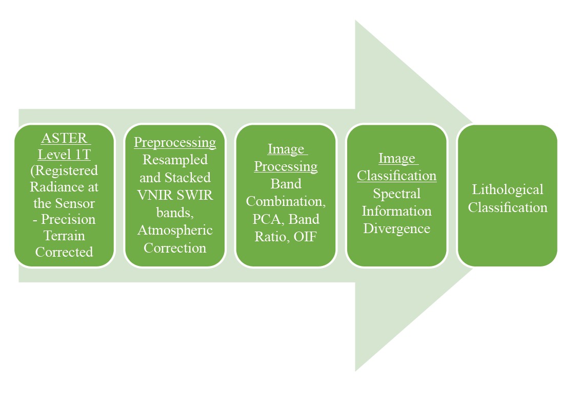
The Dry Valleys of South Victoria Land in Antarctica, one of the most extreme deserts on Earth, offers an unparalleled analog for Martian landscapes and a vital record of Earth's geological history. Characterized by a cold, arid climate and minimal atmospheric moisture, the region's ancient rock formations, including early Paleozoic granitoid plutons, Devonian to Triassic sedimentary rocks of the Beacon Supergroup, and Jurassic basalt flows, provide insights into Earth's evolution. The logistical challenges of traditional field-based geological surveys in this remote and fragile environment emphasize the need for sustainable exploration methods. This study leverages Advanced Spaceborne Thermal Emission and Reflection Radiometer (ASTER) remote sensing technology to achieve high-resolution lithological mapping while minimizing environmental impact. Image processing techniques such as Band Ratio (BR) analysis, Principal Component Analysis (PCA), and the Optimal Index Factor (OIF) were employed to enhance the spectral characterization of lithologies. These approaches facilitated the identification of key lithological units, including sandstone, granite, gneisses, and basaltic flows, and the production of an accurate lithological map. By integrating remote sensing with sustainable scientific practices, this research demonstrates the potential to advance planetary sustainability while uncovering critical geological insights in extreme environments.
References
Abrams, M., & Yamaguchi, Y. (2019). Twenty years of ASTER contributions to lithologic mapping and mineral exploration. Remote Sensing, 11(11), 1394. https://www.mdpi.com/2072-4292/11/11/1394
Barret, P. J., Adams, C. J., McIntosh, W. C., Swisher III, C. C., & Wilson, G. S. (1992). Geochronological evidence supporting Antarctic deglaciation three million years ago. Nature, 359, 816-818. https://www.nature.com/articles/359816a0
Cengiz, O., Sener, E., & Yagmurlu, F. (2006). A satellite image approach to the study of lineaments, circular structures and regional geology in the Golcuk Crater district and its environs (Isparta, SW Turkey). Journal of Asian Earth Sciences, 27(2), 155-163. https://doi.org/10.1016/j.jseaes.2005.02.005
Chang, C-I. (1999). Spectral information divergence for hyperspectral image analysis. IEEE 1999 International Geoscience and Remote Sensing Symposium. https://doi.org/10.1109/IGARSS.1999.773549
Chavez, P. S., Berlin, G. L., & Sowers, L. (1982). Statistical method for selecting Landsat MSS ratios. Journal of Applied Photographic Engineering, 8, 23-30.
Crosta, A. P., De Souza Filho, C. R., Azevedo, F., & Brodie, C. (2003). Targeting key alteration minerals in epithermal deposits in Patagonia, Argentina, using ASTER imagery and principal component analysis. International Journal of Remote Sensing, 24(21), 4233-4240. https://doi.org/10.1080/0143116031000152291
Denton, G. H., Sugden, D. E., Marchant, D. R., Hall, B. L., & Wilch, T. I. (1993). East Antarctic Ice Sheet sensitivity from a Dry Valleys perspective. Geografiska Annaler: Series A, Physical Geography, 75(4), 155-204. https://doi.org/10.1080/04353676.1993.11880393
Di Tommaso, I., & Rubinstein, N. (2007). Hydrothermal alteration mapping using ASTER data in the Infiernillo porphyry deposit, Argentina. Ore Geology Reviews, 32(1-2), 275-290. https://doi.org/10.1016/j.oregeorev.2006.05.004
El Atillah, A., El Morjani, Z. E. A., & Souhassou, M. (2019). Use of the sentinel- 2A multispectral image for litho-structural and alteration mapping in Al Glo’a map sheet (1/50,000) (Bou Azzer–El Graara Inlier, Central Anti-Atlas, Morocco). Artificial Satellites, 54(3), 73-96. https:// doi.org/10.2478/arsa-2019-0007
Feng, X., He, L., Cheng, Q., Long, X., & Yuan, Y. (2020). Hyperspectral and multispectral remote sensing image fusion based on endmember spatial information. Remote Sensing, 12(6), 1009. https://doi.org/10.3390/rs12061009
Githenya, L. K., Kariuki, P. C., & Waswa, A. K. (2019). Application of remote sensing in mapping hydrothermal alteration zones and geological structures as areas of economic mineralization in Mwitika-Makongo Area, SE Kenya. Journal of Environment and Earth Science, 9(11). https://doi.org/10.7176/JEES/9-11-03
Gupta, R., Tiwari, R., Saini, V., & Srivastava, N. (2013). A simplified approach for interpreting principal component images. Advances in Remote Sensing, 2, 111-119. http://dx.doi.org/10.4236/ars.2013.22015
Islam, N. U., Zhang, Q., Qiu, W., Liu, L., Khalil, Y. S., Ahmad, S. M., & Ahmad, W. (2024). Mineralogical mapping and lithological discrimination by using ASTER remote sensing data in the Chitral region, Khyber Pakhtunkhwa, Northern Pakistan. Earth Science Informatics, 17, 6075-6094. https://doi.org/10.1007/s12145-024-01483-4
Khaleghi, M., Ranjbar, H., Abedini, A., & Calagari, A. A. (2020). Synergetic use of the SENTINEL-2, ASTER, and LANDSAT-8 data for hydrothermal alteration and iron oxide minerals mapping in a mine scale. Acta Geodynamica et Geomaterialia, 17(3), 311-328. https://doi.org/10.13168/AGG.2020.0023
Kumar, C., Chatterjee, S., Oommen, T., & Guha, A. (2020). Automated lithological mapping by integrating spectral enhancement techniques and machine learning algorithms using AVIRISNG hyperspectral data in Gold-bearing granite-greenstone rocks in Hutti, India. International Journal of Applied Earth Observation and Geoinformation, 86, 102006. https://doi.org/10.1016/j.jag.2019.102006
Marchant, D. R., Lewis, A. R., Phillips, W. M., Moore, E. J., Souchez, R. A., Denton, G. H., Sugden, D. E., Potter Jr, N., & Landis, G. P. (2002). Formation of patterned ground and sublimation till over Miocene glacier ice in Beacon Valley, southern Victoria Land, Antarctica. Geological Society of America Bulletin, 114(6), 718-730. https://pubs.geoscienceworld.org/gsa/gsabulletin/article-abstract/114/6/718/183879
Marchant, D. R., Swisher, C. C., Lux, D. R., West, D. P., & Denton, G. H. (1993). Pliocene Paleoclimate and East Antarctic ice-sheet history from surficial ash deposits. Science, 260(5108), 667-670. https://www.science.org/doi/abs/10.1126/science.260.5108.667
Nemmour-Zekiri, D., & Oulebsir, F. (2020). Application of remote sensing techniques in lithologic mapping of Djanet Region, Eastern Hoggar Shield, Algeria. Arabian Journal of Geosciences, 13, 632. https://doi.org/10.1007/s12517-020-05648-5
Pour, A. B., & Hashim, M. (2011). Identification of hydrothermal alteration minerals for exploring of porphyry copper deposit using ASTER data, SE Iran. Journal of Asian Earth Sciences, 42(6), 1309-1323. https://doi.org/10.1016/j.jseaes.2011.07.017
Pour, A. B., Hashim, M., Park, Y., & Hong, J. K. (2017). Mapping alteration mineral zones and lithological units in Antarctic regions using spectral bands of ASTER remote sensing data. Geocarto International, 33(12), 1281-1306. https://doi.org/10.1080/10106049.2017.1347207
Pour, A. B., Park, Y., Park, T-Y. S., Hong, J. K., Hashim, M., Woo, J., & Ayoobi, I. (2019). Evaluation of ICA and CEM algorithms with Landsat-8/ASTER data for geological mapping in inaccessible regions. Geocarto International, 34(7), 785-816. https://doi.org/10.1080/10106049.2018.1434684
Sabins, F. F. (1999). Remote sensing for mineral exploration. Ore Geology Reviews, 14(3-4), 157-183. https://doi.org/10.1016/S0169-1368(99)00007-4
Schafer, J. M., Ivy-Ochs, S., Wueler, R., Leya, I., Baur, H., Denton, G. H., & Schlucher, C. (1999). Cosmogenic noble gas studies in the oldest landscape on earth: Surface exposure ages of the Dry Valleys, Antarctica. Earth and Planetary Science Letters, 167(3-4), 215-226. https://doi.org/10.1016/S0012-821X(99)00029-1
Shao, S., Guo, Y., Zhang, Z., & Yuan, H. (2019). Single remote sensing multispectral image dehazing based on a learning framework. Mathematical Problems in Engineering. https://onlinelibrary.wiley.com/doi/abs/10.1155/2019/4131378
Sheikhrahimi, A., Pour, A. B., Pradhan, B., & Zoheir, B. (2019). Mapping hydrothermal alteration zones and lineaments associated with orogenic gold mineralization using ASTER data: A case study from the Sanandaj-Sirjan Zone, Iran. Advances in Space Research, 63(10), 3315-3332. https://doi.org/10.1016/j.asr.2019.01.035
Singh, A., & Harrison, A. (1985). Standardized principal components. International Journal of Remote Sensing, 6(6), 883-896. https://doi.org/10.1080/01431168508948511
Summerfield, M. A., Stuart, F. M., Cockburn, H. A. P., Sudgen, D. E., Denton, G. H., Dunai, T., & Marchant, D. R. (1999). Long-term rates of denudation in the Dry Valleys, Transantarctic Mountains, southern Victoria Land, Antarctica based on in-situ-produced cosmogenic 21Ne. Geomorphology, 27(1-2), 113-129. https://doi.org/10.1016/S0169-555X(98)00093-2
Talalay, P. G. (2016). Mechanical ice drilling technology. Springer Singapore. https://link.springer.com/content/pdf/10.1007/978-981-10-0560-2.pdf
Tangestani, M. H., Mazhari, N., Agar, B., & Moore, F. (2008). Evaluating Advanced Spaceborne Thermal Emission and Reflection Radiometer (ASTER) data for alteration zone enhancement in a semiarid area, northern Shahr‐e‐Babak, SE Iran. International Journal of Remote Sensing, 29(10), 2833-2850. https://doi.org/10.1080/01431160701422239
Webb, P. N., Harwood, D. M., McKelvey, B. C., Mercer, J. H., & Stott, L. D. (1984). Cenozoic marine sedimentation and ice volume variation on the East Antarctic craton. Geology, 12(5), 287-291. https://pubs.geoscienceworld.org/gsa/geology/article-abstract/12/5/287/191234
Wright, R., Rothery, D. A., Blake, S., Harris, A. J. L., & Pieri, D. C. (1999). Simulating the response of the EOS Terra ASTER sensor to high-temperature volcanic targets Geophysical Research Letters, 26(12), 1773-1776. https://doi.org/10.1029/1999GL900360
Zhu, C., Liu, F., Zhang, Y., Wei, M., Zhang, X., Ling, C., & Li, A. (2016). Nitrogen-doped chitosan-Fe(III) composite as a dual-functional material for synergistically enhanced co-removal of Cu(II) and Cr(VI) based on adsorption and redox. Chemical Engineering Journal, 306, 579-587. https://doi.org/10.1016/j.cej.2016.07.096
Zoheir, B., Abd El-Wahed, M., Pour, A. B., & Abdelnasser, A. (2019). Orogenic gold in transpression and transtension zones: Field and remote sensing studies of the Barramiya–Mueilha sector, Egypt. Remote Sensing, 11(18), 2122. https://www.mdpi.com/2072-4292/11/18/2122
Downloads
Published
How to Cite
Issue
Section
License
Copyright (c) 2025 Planetary Sustainability

This work is licensed under a Creative Commons Attribution-ShareAlike 4.0 International License.